FATMAP Overview
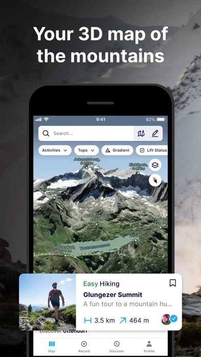
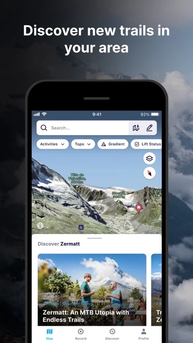
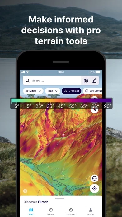
What is FATMAP? FATMAP is an app designed for mountain sports enthusiasts. It offers a global 3D outdoor map with real-time information and offline maps for hiking, biking, trail running, skiing, ski touring, and freeriding. The app also provides advanced terrain analysis tools, including slope, elevation, avalanche, and more. Users can record and re-live all their adventures in 3D and share them with the community. FATMAP Explore is a paid membership that offers additional features such as topo map layers, real-time snow conditions, real-time resort status, offline maps, and discounts on outdoor gear.
Features
- Global 3D outdoor map with real-time information and offline maps
- Mountain biking, trail running, hiking, resort and backcountry skiing maps
- Stunning satellite terrain imagery, in summer and winter
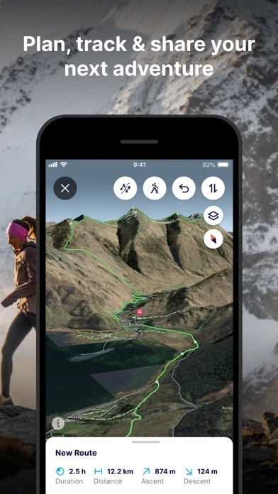
- Record and re-live all your adventures in 3D
- Advanced terrain analysis tools including slope, elevation, avalanche and more
- Follow people to see their latest adventures
- Search and find the right route for you or be inspired by the community
- Create and share custom locations / waypoints
- Locate yourself on the map at any time
- Use peak names, roads, footpaths, rivers and heaps of other map data to quickly orientate yourself and navigate to your next objective
- Understand the terrain like never before to make better decisions with Gradient, Avalanche, Flats, Aspect and more layers
- Track your adventure in the app or connect with Suunto, Garmin or Strava to see your tracks in 3D
- Share amazing fly-throughs of your adventure
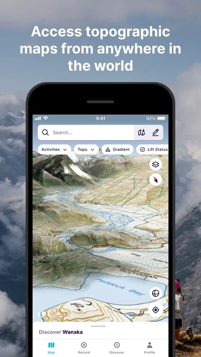
- Global Topo map or see official topo maps from swisstopo, USGS, IGN, basemap.it and more in 3D (FATMAP Explore feature)
- Real-time snow conditions (FATMAP Explore feature)
- Real-time resort status (FATMAP Explore feature)
- Download any part of the map and use it without an internet connection (FATMAP Explore feature)
- Discounts on outdoor gear (FATMAP Explore feature)
Official Screenshots
Product Details and Description of
this app is the #1 app for mountain sports. Explore the mountains with confidence with the world's most advanced 3D outdoor map. Plan the perfect route, orientate and navigate along the way, record your day and share it with the community. Whether hiking, biking, trail running, skiing, ski touring or freeriding, if you love mountain adventures, you'll find your community on this app. - Global 3D outdoor map with real-time information and offline maps - Mountain biking, trail running, hiking, resort and backcountry skiing maps - Stunning satellite terrain imagery, in summer and winter - Record and re-live all your adventures in 3D - Advanced terrain analysis tools including slope, elevation, avalanche and more - Follow people to see their latest adventures GLOBAL MAP FOR THE OUTDOORS - Know the area like a local and plan your route in detail with the most advanced 3D outdoor map that helps you intuitively understand the terrain - Find any outdoor trail: footpaths, hiking trails, singletrack and more - Discover outdoor points of interest like mountain huts and campsites - Choose between summer or winter/snow map imagery (where available) FIND YOUR NEXT MOUNTAIN ADVENTURE - Search and find the right route for you or be inspired by the community PLAN & NAVIGATE - Create and share custom locations / waypoints - Locate yourself on the map at any time - Use peak names, roads, footpaths, rivers and heaps of other map data to quickly orientate yourself and navigate to your next objective - Navigate trails while riding, hiking, running or skiing UNDERSTAND THE TERRAIN LIKE AN EXPERT - Understand the terrain like never before to make better decisions with Gradient, Avalanche, Flats, Aspect and more layers. RE-LIVE YOUR ADVENTURE IN 3D - Track your adventure in the app or connect with Suunto, Garmin or Strava to see your tracks in 3D - Share amazing fly-throughs of your adventure GO FURTHER WITH this app EXPLORE this app Explore is for everyone who wants more out of their outdoor experiences. TOPO MAP LAYERS - Use the Global Topo map or see official topo maps from swisstopo, USGS, IGN, basemap.it and more in 3D REAL-TIME SNOW CONDITIONS - See current snow depth, fresh snow, and snow forecast directly on the map. REAL-TIME RESORT STATUS - See which lifts and pistes/runs are open or closed in real time. (At supported Ski Resorts) OFFLINE MAPS - Download any part of the map and use it without an internet connection. - Conserve battery by using the app in airplane mode THE BEST DEALS ON OUTDOOR GEAR - Explore members receive discounts in major partner brands like Mammut, Salomon, Suunto, Faction Skis and many more. (Access to this app Explore requires a paid membership.) - REVIEWS - “this app has changed the way I see and act in the mountains” - Xavier De Le Rue, The North Face Athlete “Useful and inspiring (and also looks really really cool.)” - Forbes "[this app] may be the most ambitious adventure tech to hit the market since sat phones" - Outside Online “An app that will revolutionise your backcountry freeriding experience” - Red Bull ** For technical support, contact: support@this app.com this app Explore is available as a 12-month subscription. You can subscribe and pay through your iTunes account. Payment will be charged to your iTunes account at confirmation of purchase. Your subscription will automatically renew unless cancelled at least 24 hours before the end of the current period. You may manage your subscriptions and turn off auto-renew after purchase by going to the ‘Manage Subscription’ page in settings. Any unused portion of a free trial period, if offered, will be forfeited if you purchase a subscription, where applicable. The subscription will renew at the same cost." Terms of Service: https://about.this app.com/terms Privacy Policy: https://about.this app.com/privacy
Top Reviews
By john2scu
Best app for exploring outdoor terrain
I now go into my outdoor activities much more informed, and enjoy them a lot more too. I appreciate the level of zoom detail, 3D capability, fly-over feature, Terrain Layers, and Snow Depth. Truly exceptional features. Thanks for this awesome app! It would be great to be able to overlay the Distance layer on top of the Snow Depth layer. That way I know how long I’ll be traveling over snow to get to my destination. Toggling between the two layers gives me a rough idea but is kinda cumbersome.
By svendleton
Best outdoor planning app
Being in the mountains all the time, you realize how helpful and safe it is to have a plan of where you are going, where you are sleeping, and how you can get out. this app helps with all of those. It’s like being able to hold the world in your hand and look into any tiny piece of detail before you get there. It’s great
By Nyakimiv
Great potential, needs improvement
Exactly as the title says, the idea is there, but needs a lot of work. I have faith in this one, meanwhile I’ll use my usual go to apps and keep an eye on this one. I’m in NYC, very little coverage on this app here, but again, this is a relatively new app and I’m sure it’ll keep expanding its database and functionality.