National Hurricane Center Data Software
Company Name: LW Brands, LLC
About: Full-service marketing solutions
Headquarters: Bonita Springs, Florida, United States.
National Hurricane Center Data Overview
In total, there are now over 100+ hurricane / weather tracking products to help you stay informed during hurricane season.
More than sixty (60+) new hurricane tracking products were added for the 2020 Hurricane Season.
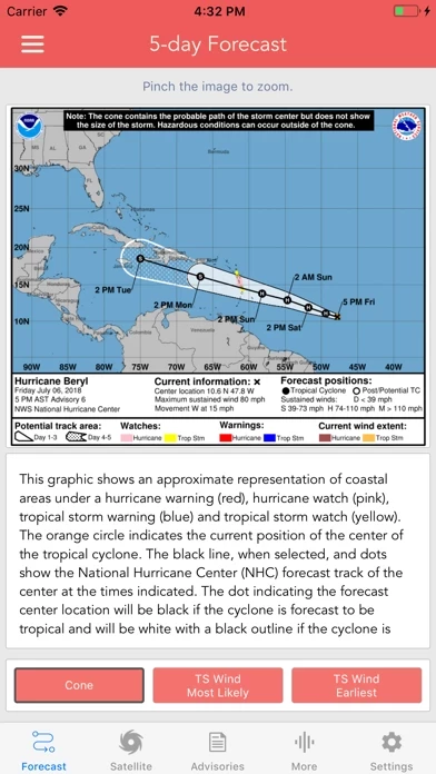
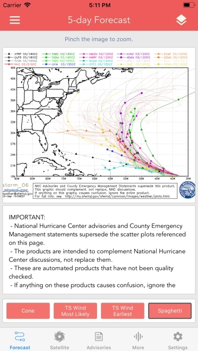
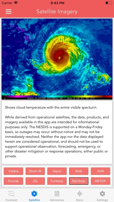
Models included in spaghetti graphics include: HWRF, HMON, CTCX, AVNO, SHF5 & OFCL.
* Track, Intensity and Pressure graphics include spaghetti plots when available.
Note: Local threat graphics are typically not available until shortly before storm landfall.
Official Screenshots
Product Details and Description of
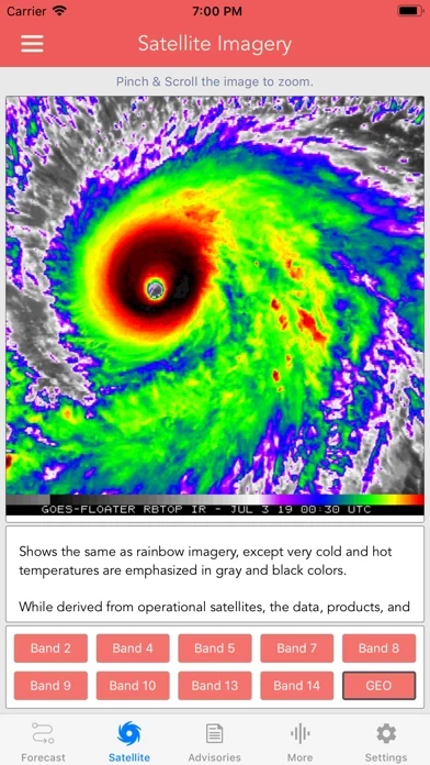
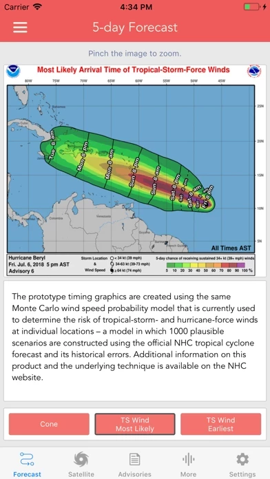
Download the most comprehensive Hurricane Tracker app for iOS. MAIN FEATURES INCLUDE: + GOES Satellite Imagery Animations + National Hurricane Center Products + National Weather Service Alerts + Weather Prediction Center Graphics + Tropical Weather Push Notifications + Satellite Imagery Home Screen Widget + Spaghetti Models GRAPHICAL PRODUCTS INCLUDE: Forecast Graphics - Spaghetti Models - 5-Day Tropical Weather Outlook - 3-Day Excessive Rainfall Outlook - 7-Day Quantitative Precipitation Forecast Storm Specific Graphics - Key Messages - Cone Track Forecast - Tropical Storm Wind (Most Likely) - Tropical Storm Wind (Earliest) - Hurricane Wind Probability - Surface Wind Field - Surface Wind Analysis - Wind / Track History - Rainfall Forecast - Flash Flood Risk Local Storm Threat Graphics - Flooding Rain Threat - Wind Threat - Surge Threat - Tornado Threat - Rainfall Totals - Wind Warnings Note: Local threat graphics are typically not available until shortly before storm landfall. TEXT PRODUCTS INCLUDE: - Tropical Weather Outlook - Forecast Advisories - Public Advisories - Forecast Office Discussion - Local Statement (HLS) - Local Warnings (TCV) - Tropical Discussion - Wind Analysis WEATHER MAP OVERLAYS INCLUDE: - Hurricane Track & Intensity - Potential Storm Surge Flooding - NASA Sea Surface Temperature - NOAA Weather Radar GOES SATELLITE IMAGERY INCLUDES: Fifteen (15) Satellite Imagery Filters - Visible (Band 2) - Near IR (Bands 4 & 5) - Infrared (Bands 7, 8, 9, 10, 13, 14 & 16) - Nighttime Microphysics - Day Cloud Phase - True Color - Air Mass - Sandwich APPLE WATCH APP INCLUDES: - View wind speed & intensity updates every 30 minutes - View the latest satellite imagery - Choose from a variety of Watch Complications -- PRO SUBSCRIPTION FEATURES -- Full Screen, High Resolution Satellite Imagery: - Latest Image - Animated Loop - Mesoscale: Near Real-time Imagery - Geostationary Lightning Mapper (GLM) Mesoscale imagery typically has 1-minute temporal resolution, but is not always available for each storm. 16-day Weather Forecast Models: - Global Forecast System (GFS) - Global Ensemble Forecast System (GEFS) - North American Ensemble (NAEFS) Weather Simulation Forecast Models: - Hi-Res Rapid Refresh (HRRR) - Hi-Res Ensemble Forecast (HREF) - North American Mesoscale (NAM) - Hi-Res North American Mesoscale (NAM-HIRES) - High Resolution Window (HRW-FV3, HRW-ARW, HRW-ARW2) - WaveWatch III (WW3) - European Centre for Medium-Range Weather (ECMWF) HMON & HWRF Hurricane Forecast Models Experimental Forecast Animations: - Simulated Radar 2km - Surface Pressure, Wind - 200mb Temp, Ht, Wind - 700mb RH, Ht, Wind - 850mb Vort, Wind, Thick Model Analysis & Guidance Animations: - 6h Total Precipitation - 10m Wind - 200mb Vort, Wind, Ht - 500mb Relative Humidity - 700mb Vort, Wind, Ht - 850mb Vort, Wind, Ht Static Forecast Products - Track* - Intensity* - Pressure* - Rain - Wind * Track, Intensity and Pressure graphics include spaghetti plots when available. Models included in spaghetti graphics include: HWRF, HMON, CTCX, AVNO, SHF5 & OFCL. NCEP / EMC Cyclogenesis Tracking Products - 16-day Storm Forecast Tracks - 21-day Global Tropics Hazards Outlook - 35-day Probability of Formation CIMSS Tropical Cyclone Products - Wind Vorticity & Shear Analysis - Steering Layer Analysis - Morphed Integrated Microwave Imagery - Advanced Dvorak Technique (ADTV9.0) ADT Includes imagery, wind radii estimates & trends Interactive Hurricane Tracker Map - Track & Intensity Forecast - Preliminary Best Track Analysis TERMS & CONDITIONS https://lwbrandsllc.com/hurricane-app-terms-conditions/ -- In total, there are now over 100+ hurricane / weather tracking products to help you stay informed during hurricane season.
Top Reviews
By iknowmytunes!
All time favorite app, till death do us part
This app is incredible, absolutely marvelous. Not only is it amazing at updating you on hurricanes all the way through their development visually, it also informs you on every detail in writing. It has satellite images of the entire United States, Mexico and Caribbean, as well as a few others and they are constantly updated. It even lets you know when there are typhoons on the other side of the globe. I can’t understand anyone that doesn’t love this app. It’s pure perfection. Get it. Don’t even think about it.
By Ca-33435
Accurate data
I’ve enjoyed this app and have found it to be accurate and a useful tool to navigate hurricane information without all the commercials of regular news /weather apps . Sticking to the data is the best plan when monitoring a storm. I’m in the middle of hurricane Dorian , ot is providing me with the most updated and accurate information . The app developer was kind enough to email a quick reply to a simple question I had . great customer service also... kudos to you !!
By FlrMndCane
Way better than trudging through the web site
Have had this for a while, but TS Cristobal had me pull it out and really check it out. Seems to have everything I use. I know the NOAA guys work hard on the website, but it’s still a 1990s mostly Text, too busy, cryptic, and all too often multiple click paths to find something or even worse look up what something is. SMH Three thoughts to improve it. 1) (important to me) am old and zoom all the time on my iPad/iPhone. Needs zoom feature. 2) (nice to have) Would be nice if there was an info button with each product that includes either a simple description or pulls the website’s description and displays it. 3) (would pay extra) Add ability to download product in max res to a PDF file.