Hiking & Skiing - PeakVisor Software
Company Name: Routes Software SRL
About: 3D Maps & Peaks Identification
Headquarters: , , .
Hiking Skiing Overview
What is Hiking Skiing? PeakVisor is an app that uses augmented reality technology to display the names and elevation of nearby peaks. It provides state-of-the-art 3D maps and mountain identification features to help users navigate the outdoors. The app allows users to identify mountains, plan hiking routes, track their outdoor adventures, and even identify mountains in photos. It is available for offline use and is useful for winter sports as well.
Features
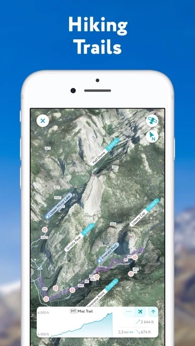
- 3D mapping of hikes
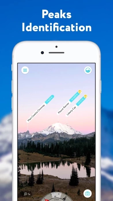
- Mountain identification from hundreds of miles away
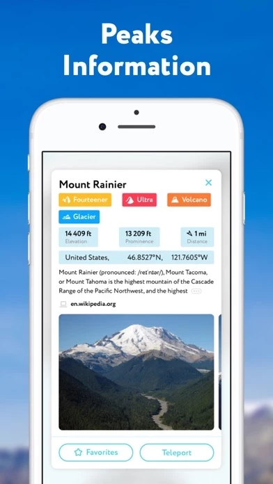
- Detailed profiles for each mountain, including altitude, topographic prominence, mountain range, national parks or reserves it may belong to, photos, and additional Wikipedia articles
- Planning of hiking routes with distance, elevation profile, and estimated time for completion
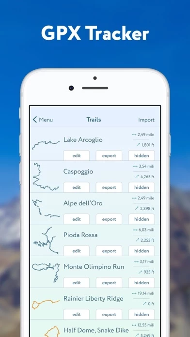
- GPS tracker to track outdoor adventures and import/export GPX files
- Offline use
- Identification of mountains in photos
- Useful for winter sports with detailed information about mountain lifts, ski runs, and popular backcountry skiing opportunities
- PeakVisor PRO premium subscription for unlimited use of the app
- Automatic renewal of subscription unless canceled at least 24 hours before the end of the current period
- Management and cancellation of subscriptions through App Store account settings
- Terms and Privacy Policy available at https://peakvisor.com/en/terms.html
- Contact at [email protected] for questions or discussions about mountains.
Official Screenshots

Product Details and Description of
PeakVisor will make you a superhero of outdoor navigation by putting state-of-the-art 3D maps and mountain identification magic wand in your hand. "PeakVisor uses your iPhone's camera and augmented reality (AR) technology to display names and elevation of nearby peaks. The information will appear on your phone like magic." - App Store, Take the Trail Less Traveled Key Steps to Becoming a Superhero: ● 3D Map your Hike Get your topo maps of the future. The cutting-edge technology with high-precision terrain modeling allows simple yet effective insight into the landscape of the mountains. It is the most convenient way to explore a mountainous area, its trails, summits, passes, viewpoints, and even parking areas. ● Identify Mountains hundreds of miles away Identify more than a million mountains & hills all over the world and get a detailed profile for each of them, including altitude, topographic prominence, mountain range, what national parks or reserves it may belong to, as well as photos and additional Wikipedia articles. ● Plan Hiking Routes A vast network of worldwide hiking trails and walking pathways included in PeakVisor’s 3D Maps will help you compose a hiking route which includes evaluating the distance you can expect to hike as well as a route’s elevation profile and estimated time for completion. ● Use GPS Tracker to share your epic adventures Track your outdoor adventures, see your stats such as elevation gain and walking distance as well as your path in the 3D world. The app also allows you to import and export GPX files. ● Everything works Offline All the data is downloadable and ready for off the grid journeys. ● Identify Mountains in Photos If you have photos from previous hikes that you have not taken through the app, you can still find out what peaks you have been by importing your images into the PeakVisor app. ● Ski and Snowboard when Winter Comes PeakVisor is extremely useful for any kind of winter sports in the mountains. Topographic 3D Maps allow for a better understanding of the terrain and provide detailed information about mountain lifts, ski runs, and popular backcountry skiing opportunities. No matter where you go and how hard you challenge yourself this winter, PeakVisor will be the perfect booster for your outdoor adventures. PeakVisor is the Swiss army knife of outdoor adventure and will soon be indispensable to all your future hiking needs. Just keep it in your backpack and you'll get value from it every time you’re on the trail! PeakVisor PRO is a premium subscription that allows you to use the app without any limitations. By subscribing to PeakVisor PRO you make it possible for us to focus on ever-excelling the app. PeakVisor PRO is available as a monthly or an annual subscription. If you choose to get PeakVisor PRO, the payment will be charged to your Apple ID account once you confirm your purchase. The subscription automatically renews unless it is canceled at least 24 hours before the end of the current period. Your account will be charged for renewal within 24 hours before the end of the current period. You can manage and cancel your subscriptions through the App Store account settings after purchase. Any unused portion of a free trial period, if offered, will be forfeited when the user purchases a subscription to the publication, where applicable. You may find more details in our Terms and Privacy Policy available by the link => https://peakvisor.com/en/terms.html If you have any questions or just feel like talking about mountains, please contact us at [email protected]
Top Reviews
By Robbo Mon
Amazing tool for learning the mountains
I have been very impressed with the breadth and abilities of this app. It has become my go-to tool for learning about the topography of mountains in California. Many times before this app, I had wondered what mountains I could see. This app makes incredibly easy to find out. Before going on trips, I enjoy using the teleport feature to see the layout of the area. You can see relatively detailed images that give you a good idea of how your path will look from each position, so it’s useful for back-country treks where good trails aren’t available. The new 3D feature is very useful here as well. There are actually quite a few trails uploaded here too, so it is useful when you want to find the direction to a trail. Both live and picture-based landscape matching work really well. I appreciate the download zone option, since there isn’t always service in the mountains. The landscapes are surprisingly accurate, and all of the features are easy to use.
By Jrobert.in.Wilton
Wonderful, but know that it uses a lot of data.
Update: The developer has explained that the data is necessarily large but that it can be pre-downloaded at home to save data quota. Since that was my only complaint I've upped my rating to 5-stars. Users on a measured plan should understand that the the app will pull a lot of data in the field if it hasn't been previously downloaded. It really is quite amazing at identifying peaks - point and shoot! - and I feel bad about dissing it. But in 3 or so minutes, over a less than 30 degree segment of the horizon, it just blew through my - admittedly low, 100MB - entire monthly data allowance. This won't be a barrier for most people but those light-users on a measured plan, as I am, should know upfront: expect a hefty download to do what it does.
By Four Corners resident
An exceptionally useful tool!!
An excellent app for learning the names of visible mountains in your vicinity. The app is easy to use and offers an outline of the peaks you’re viewing that can be moved and aligned with the camera image of the peaks to accurately position the labels on each mountain. If you live near mountains, this is a must-have app. It’s intuitive to use and saves photos of the peaks you label for review later. The only drawback is that the free version can only be used in one area per day. If you’re moving through several locations in a day (e.g. driving for an hour or more through several sets of mountains) you need to subscribe to the Pro version of the app.