Fires Overview
What is Fires? Fires is a comprehensive app that provides wildfire information and navigation features. It offers maps, photos, and information about wildfires from several sources for the United States. The app also provides incident notifications, offline incident mapping, thermal hotspots and fire activity, satellite images and animations, local weather conditions, fire weather forecasts and outlooks, historical fires, and social media updates. Additionally, it offers offline GPS functionality and 3D base maps for navigation.
Features
- Wildfire information resource from several sources
- Incident notifications with containment updates and fire weather notifications
- Offline incident mapping
- Thermal hotspots and fire activity
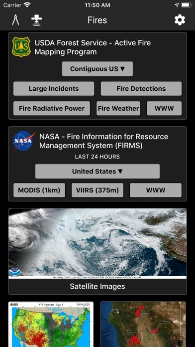
- GOES and Himawari satellite images and animations
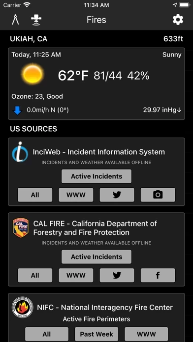
- Local weather conditions
- Fire weather forecasts and outlooks
- Historical fires
- Social media updates
- Offline GPS functionality and 3D base maps for navigation
- Subscriptions for additional features such as access to satellite hybrid base map, topo base map, streets base map, hillshades overlay, incident weather conditions, and ad removal.
Official Screenshots


Product Details and Description of
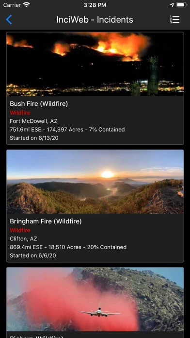
this app is a comprehensive wildfire information resource and navigation app. ▶▶ WILDFIRE INFORMATION RESOURCE ▶ Incident Details this app provides maps, photos, and information about wildfires from several sources for the United States. View active wildfire perimeters or share wildfire information and high resolution photos. • InciWeb • CAL FIRE • NIFC • US Forest Service ▶ Incident Notifications with Containment Updates and Fire Weather Notifications this app will notify you when new incidents are downloaded within the maximum distance that you set from the source that you select. • InciWeb • CAL FIRE • US Forest Service ▶ Offline Incident Mapping this app can automatically download incidents when the app is in the background from the source that you select. • InciWeb • CAL FIRE • US Forest Service ▶ Thermal Hotspots and Fire Activity this app allows you to interactively browse the full set of global active fire detections from MODIS and VIIRS. • Collection-6 MODIS Active Fire Data • VIIRS I-Band 375m Active Fire Data • Active Fire Details ▶ GOES and Himawari Satellite Images and Animations this app provides extensive near real-time GOES (Geostationary Operational Environmental Satellite) imagery from NOAA. • United States • Pacific • Atlantic • Central America • South America • East Full Disk • West Full Disk ▶ Local Weather Conditions this app gives you a summary of your current local weather conditions from AccuWeather for free without a subscription. ▶ Fire Weather Forecasts & Outlooks this app provides Fire Weather Forecast & Outlook maps intended to delineate areas of the US. • Expected Number of Large this app per PSA • Fire Potential Index Forecast • Fire Danger Rating • Large Fire Probability • National Significant Wildland Fire Potential Outlook • Drought Monitor Summary • Dead Fuel Moisture ▶ Historical this app this app provides maps, photos, and information about historical wildfires from CAL FIRE for 2017-2020, and quick access to historical fire perimeters from 2000-2018. ▶ Social Media Updates this app provides quick access to social media updates from national and state agencies. • Twitter • Facebook • Instagram ▶▶ NAVIGATION APP ▶ Offline 3D Maps and GPS this app will give you offline GPS functionality and 3D base maps when there is no network coverage. this app allows you to cache what you use and doesn't require you to manually save your maps, which saves you a lot of time. • Several Base Maps • Create Lines, Shapes, and Waypoints • Navigate and trace your locations ▶▶ SUBSCRIPTIONS Subscriptions automatically renew unless auto-renew is turned off at least 24 hours before the end of the current period. Your iTunes account will be charged for renewal within 24 hours of the end of the current period, and identify the cost of the renewal. ▶ this app PRO ($14.99/year) • Access Satellite Hybrid base map • Access Topo base map • Access Streets base map • Access Hillshades overlay • Access Incident Weather Conditions • Remove Ads ▶ SATELLITE BASE MAP ($4.99/6 months) • Access Satellite (No Labels) base map ▶ INCIDENT WEATHER CONDITIONS ($5.99/year) • Access Incident Weather Conditions ▶ REMOVE ADS ($2.99/year) • Use the app without ads ▶ TO MANAGE YOUR SUBSCRIPTION: • TURN OFF auto-renewal via the main Settings app: http://support.apple.com/kb/ht4098 • Subscriptions automatically renew unless auto-renew is turned off at least 24 hours before the end of the current period. Your iTunes account will be charged for renewal within 24 hours of the end of the current period, and identify the cost of the renewal. • Your iTunes Account will be charged at confirmation of purchase. • Visit the following URL to view our Privacy Policy: http://www.livewaremedia.com/p/privacy-policy.html • Visit the following URL for full terms of use: http://www.livewaremedia.com/p/terms-and-conditions.html
Top Reviews
By ThumperAlan7
Awesome Pics!
This app keeps getting better and better! I like that it has now separated the this app into prescribed this app and wildfires, all of the info about each fire, and now I’m loving being able to see all of the pictures taken at each fire! It’s great to see the firefighters working hard and getting the job done. So great to see the great work these brave people do. 😃
By Silverback surfer
Traveler
Drove across America and used this APP everyday everywhere to plan our driving and camping. We didn’t want to go to areas that had crowding from people running for their lives and consume their stores supplies and camping spots. Definitely a useful tool for road tripping. Don’t want to drive into an oven. Be safe.
By Cara-edw
Accurate maps
It's great to find an app with such accurate and up to date information. I would definitely recommend this app to anyone that is looking for wildfire maps.