Compass 55. Map & GPS kit. Software
Company Name: Kalimex-Consulting s.r.o. @Blocoware & Stanislav Dvoychenko
Compass 55 Map GPS kit Overview
What is Compass 55 Map GPS kit? The app is an all-in-one assistant that includes a map, compass, GPS coordinates, altitude, distance, sunset/sunrise, speedometer, navigator, and more. It also has a PRO Pack upgrade that adds additional capabilities such as recording and sharing GPS tracks, showing ETA to a target, and support for Siri shortcuts in IOS 12.
Features
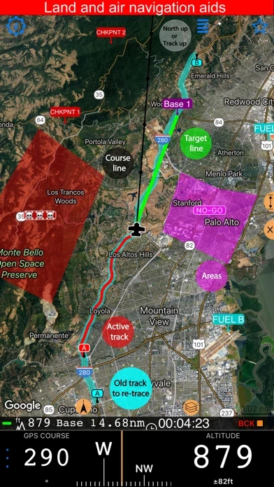
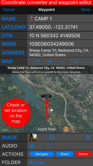
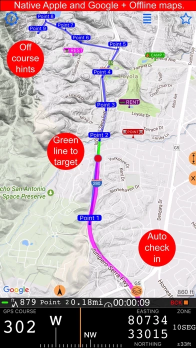
- Map with advanced target/waypoint editor and photo/audio note capabilities
- Share location via email, text message, Facebook, or Twitter in UTM, MGRS, or Latitude/Longitude formats
- Speedometer with options to control average and max speed and pace counters
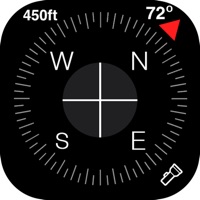
- Compass with instant reaction and automatic direction pickup based on magnetic or GPS course
- Magnetic declination δ for current location and any location on the map
- Sunset and sunrise information for travel planning
- Arrow pointing to target waypoint with distance and bearing information
- Create/measure routes and areas
- Barometric Vertical Speed Indicator (VSI, IVSI) in both scale and graph forms
- PRO Pack upgrade with additional capabilities such as recording and sharing GPS tracks, showing ETA to a target, and support for Siri shortcuts in IOS 12
- Background mode for automatic tracking while using other apps
- Privacy protection with location data used solely for direction and GPS tracking within the app
- Compatible with iPhone and cellular iPad, but not iPods or wifi-only iPads without external GPS module
- Note that continued use of GPS running in the background can decrease battery life.
Official Screenshots


Compass 55 Map GPS kit Pricing Plans
| Duration | Amount (USD) |
|---|---|
| Billed Once | $9.99 |
**Pricing data is based on average subscription prices reported by Justuseapp.com users..
Product Details and Description of
All-in-one assistant with a map, compass, GPS coordinates to view and share in 6 formats, altitude, distance, sunset/sunrise, speedometer with top and average speed, navigator to your target or along the route and a whole lot more! + Advanced target/waypoint editor. Can be also used as a coordinates converter. You can use map to check or set waypoint location and add photo or audio note. + Share your location via email, text message, Facebook or Twitter. This includes UTM, MGRS and Latitude/Longitude (MENU>Share my location). + You can use UTM, MGRS or Lat/Long, just pick your preference in settings (Coordinate Format). + Speedometer. Shows you the speed and pace. Speedometer also gives you options to control average and max speed and pace counters (MENU > RESET and PAUSE/RESUME counters). + Compass. Instant reaction compass, no delays. Automatically pickups the direction based on magnetic or GPS course. If you mostly walk or drive, you can change this automatic mode in app settings > Compass or GPS course. NATO mils? Same place in settings to set. + Magnetic declination δ for the current location and any location on the map (via World Magnetic Model, WMM, no need for data/internet). + Sunset and sunrise. So you can plan your travel better. + Arrow pointing to your target waypoint. Distance and bearing to it. + Create/measure routes and areas. + Barometric Vertical Speed Indicator (VSI, IVSI) in both scale and graph forms. All above belong to a basic version. PRO Pack upgrade will add following capabilities: + Recording and sharing GPS tracks. + Moving waypoints between folders. + Showing ETA to a target as this requires GPS tracking. + Native Google map with fantastic terrain map, amazing 3D and real night mode. + Adding own/custom tile map servers. + Downloading offline maps. Offline maps import in .sqlitedb, rmaps, mbtiles formats. + GPX import and export for waypoints, tracks and routes. + Google Earth KML support for waypoints and tracks import/export. KMZ support for waypoints and tracks export, waypoints import. + CSV import/export for waypoints. + Voice coach to tell you active track distance and duration, current speed and altitude without need to open the app. + Support for Siri shortcuts in IOS 12 for starting and stopping GPS tracks. + BACKGROUND MODE. App will work in background automatically when tracking. You can use other apps while Compass 55 does its job in the background! + PRIVACY. Compass 55 never shares your location data with 3rd parties or ad agencies. Location data is used solely for telling you direction to a target and recording GPS tracks and never leave the app unless you decide to share by means of a track export. It always lets you know when background mode is on and never runs in background unless the track is being recorded. ! You can use this app on your iPhone as well as on any cellular iPad. **App will not work properly on iPods and wifi only iPads as they don't have GPS (external GPS module is required). As quite a lot of us are using external GPS modules, app is available for wifi only iPads and iPods. ! Please note that as with all GPS apps, continued use of GPS running in the background can dramatically decrease battery life.
Top Reviews
By Gunslinger OG
Love the App!!
I use this app when ride off the beaten trail on my KLR 650 and it make tracking my trail and ride a breeze. I can review rides and take new paths. I also plan to use the app while driving truck to track route, time and speed. All helping make me a more efficient driver and a more adventures rider. I highly recommend the paid version of this app, with its added features it makes using the app more fun.
By Paul in LA
Find that spot in wide open spaces
I needed to mark a spot in the Coastal marsh so I could return to it on an ongoing basis. There’s hardly any reference points around that I could truly rely on for dead reckoning. This app seems to be what I’ve been looking for. Not a bad learning curve. It’s very responsive with hardly any latency in screen response. Love the feature that let’s you dial in longitude/latitude.
By Lucky123987
Great App
I’ve been using this app for hunting trips the past few years. It is a great app that has saved me several times. I have so much faith in it I leave my stand on tree in unfamiliar woods, mark it as way point come back to it in morning with no problem.