ForeFlight Mobile EFB Software
Firmenname: ForeFlight
Über: ForeFlight is a companion for pilots that packs rich airport information, search, and aviation
weather imagery is a single package.
Hauptsitz: Seminole, Texas, United States.
ForeFlight Übersicht
ForeFlight is the most widely used application by individual pilots and professional flight crews to access weather and airport information, plan flights with optimized routing, file flight plans via EUROCONTROL, access and manage electronic charts and maps, reference flight manuals and documents, avoid terrain and obstacles with powerful hazard awareness tools, access in-flight traffic (and weather where supported), and aid enroute navigation.
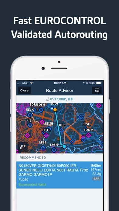
Offizielle Bildschirmfotos

Produkt einzelheiten und Beschreibung von
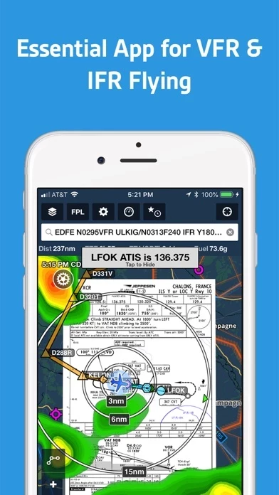
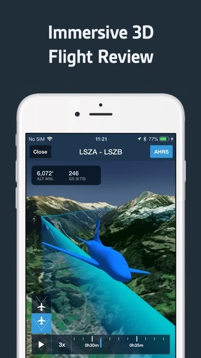
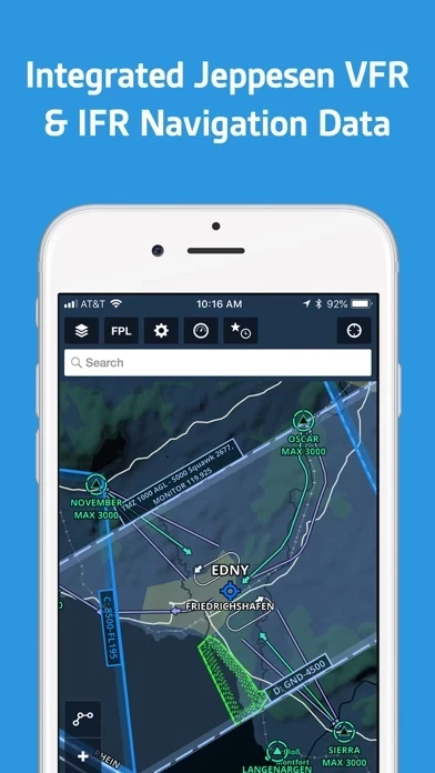
Guten Tag! diese App jetzt auch in Europa verfügbar Download the app for a 30-day free trial. diese App is the integrated flight app with all the essentials for VFR & IFR route planning, flight plan filing, and flying in Europe. diese App is the most widely used application by individual pilots and professional flight crews to access weather and airport information, plan flights with optimized routing, file flight plans via EUROCONTROL, access and manage electronic charts and maps, reference flight manuals and documents, avoid terrain and obstacles with powerful hazard awareness tools, access in-flight traffic (and weather where supported), and aid enroute navigation. diese App requires a subscription. Visit our website for more information on the available plan levels. Please note: Location is used to enable a moving map and to record track logs, push notifications are used for important bulletins and flight alerts, and contacts are used to add people to flights. CHARTS & DATA TO MEET YOUR NEEDS diese App’s state-of-the-art map engine gives the app its signature speed and fluidity when panning and zooming. Data-driven Aeronautical map uses Jeppesen’s global VFR and IFR navigation data to depict waypoints, airports, airspace, airways, arrival/departure procedures, circuits, holds, no overfly areas, and more to support VFR and IFR flying in Europe. Europe geo-region includes AIP enroute, procedure, and aerodrome charts and documents provided via EUROCONTROL. Optional add-ons include Jeppesen VFR Procedures, Jeppesen IFR Airway Manual coverages, and the German DFS VFR AIP and Charts. More countries and coverages to come. EUROCONTROL-INTEGRATED FLIGHT PLANNING, BRIEFING, & FILING Plan routes using the interactive Maps tab or the form-based Flights tab. Graphical Route Advisor produces EUROCONTROL validated routes within a matter of seconds. Simply tap the desired route to add it to your plan. File your flight plan from the mobile app or on the web and receive Calculated Take-Off Time (CTOT) notifications (if applicable to your flight). Our global, redundant AFTN connection provides fast, direct, and unlimited access to filing flight plans with no additional cost or account configuration required. diese App currently supports filing within and between any EUROCONTROL member states and Greenland. Generate a graphical preflight briefing and print a professional-grade Navlog for inflight reference. SUPERIOR WEATHER VISUALIZATION Overlay a wide selection of interactive weather layers on the Maps view, along with your route line, and quickly see if conditions will affect your flight. View animated radar, global satellite and winds aloft, icing, turbulence, isobars, METAR-based layers, and more. Color-coded METARs/TAFs with decoded text help you quickly interpret conditions. GEO-REFERENCED APPROACHES & TAXI CHARTS See the real time display of your GPS location on the chart. For ultimate situational awareness, overlay them onto the Maps view, along with weather and hazards in one integrated view. GLOBAL HAZARD AWARENESS TECHNOLOGY Top-down-view Hazard Advisor map layer, Profile View, automatic Hazard Alerts, and 3D Synthetic Vision seamlessly integrate into the map view for a clear picture of terrain and obstacle hazards anywhere in the world. Features Jeppesen’s high-resolution terrain and obstacle data. Pair with an AHRS source for a backup attitude display on Synthetic Vision. ADDITIONAL FEATURES INCLUDE: Built-in documents catalog Airport business and fuel price information Weight & Balance Over-the-air data updates using delta-downloads technology Chart color inversion for better night flying experience Access to web planner Fliegermagazin Newcomer of the Year 2018 Flying Magazine Editor's Choice 2012, 2013, 2014, 2017 "Best app for IFR" - Aviation Consumer "One of the most popular and most-respected aviation apps available" - Sporty's Pilot Shop
Oben Erfahrungen und Bewertung
durch Pilot 973
Ich bin ein Fan!
Ich kannte diese App schon aus Flügen in den USA. Damals hatte ich mir extra dafür FF abonniert. Zurück in Deutschland habe ich es dann schmerzlich vermisst, auch wenn ich mit SkyMap auch sehr zufrieden war. Mit gefällt die Integration zu allem, was man zum Fliegen braucht: Planung, Briefing, Flugplan aufgeben, Weight & Balance, Dokumente und vieles mehr. Ich bin komplett umgestiegen und vermisse kaum noch eine Funktion aus SkyMap (Ausnahme: Das Einblenden der GAFOR-Karte fehlt noch). Durch die Kopplung mit DropBox und die Customer Content Funktion kann man unwahrscheinlich viel anstellen. Das Kartenangebot für Europa wächst und wächst und man merkt, dass viele weitere Features extra für uns Europäer dazu entwickelt werden. Ach ja, und der Support ist auch super und schnell.
durch Dietmar Winsel
Pilot Support Team sensationell !!!
Ich möchte mich hier vorrangig einmal zum Pilot Support Team von diese App äußern. Meine konkrete Anfrage per E-Mail wurde bereits nach wenigen Minuten beantwortet. Die Lösung der anstehenden Frage hat mich sehr positiv überrascht. So stelle ich mir eine Kundenbetreuung vor. Sensationell gut.
durch Mirkomania
Endlich alles in einer App für den VFR Piloten
Nachdem ich jahrelang mit AirNavPro und Skydemon gearbeitet habe, und immer neidisch nach Amerika geschaut habe, wo diese App verfügbar war, war ich umso mehr gespannt auf diese App Europe. Diese App bietet alles aus einer Hand, vom Weight and Balance, Wetterbriefing, Flugplan Aufgeben, Route und Wetterbriefing, bis zu den Anflugblättern und dem Logbuch. Das Logbuch ist noch nicht ganz auf EASA Standart. Super finde ich auch den GlideAdvisor, welcher mir im Falle eines Motorausfalles stets auf der Karte zeigt, wie weit ich es bei BestGlideSpeed für mein Flugzeug noch schaffe. Gerade bei flügen in Küstengebieten sehr hilfreich. Was mir noch fehlt: - Online Based Traffic - FLARM Traffic per Wlan aus dem TRX2000 z.B. - Blockzeiten, sowie Start und Landezeit automatisch im Logbuch