How to Cancel Air Navigation Pro
Published by Xample Sarl on 2024-01-08We have made it super easy to cancel Air Navigation Pro subscription
at the root to avoid any and all mediums "Xample Sarl" (the developer) uses to bill you.
Complete Guide to Canceling Air Navigation Pro
A few things to note and do before cancelling:
- The developer of Air Navigation Pro is Xample Sarl and all inquiries must go to them.
- Cancelling a subscription during a free trial may result in losing a free trial account.
- You must always cancel a subscription at least 24 hours before the trial period ends.
Pricing Plans
**Gotten from publicly available data and the appstores.
- Free: limited features
- Premium: $49.99/year or $9.99/month, includes all features except weather
- Smart+: $99.99/year or $19.99/month, includes all features including weather
- Ultimate: $199.99/year or $39.99/month, includes all features including weather and priority support.
How to Cancel Air Navigation Pro Subscription on iPhone or iPad:
- Open Settings » ~Your name~ » and click "Subscriptions".
- Click the Air Navigation Pro (subscription) you want to review.
- Click Cancel.
How to Cancel Air Navigation Pro Subscription on Android Device:
- Open your Google Play Store app.
- Click on Menu » "Subscriptions".
- Tap on Air Navigation Pro (subscription you wish to cancel)
- Click "Cancel Subscription".
How do I remove my Card from Air Navigation Pro?
Removing card details from Air Navigation Pro if you subscribed directly is very tricky. Very few websites allow you to remove your card details. So you will have to make do with some few tricks before and after subscribing on websites in the future.
Before Signing up or Subscribing:
- Create an account on Justuseapp. signup here →
- Create upto 4 Virtual Debit Cards - this will act as a VPN for you bank account and prevent apps like Air Navigation Pro from billing you to eternity.
- Fund your Justuseapp Cards using your real card.
- Signup on Air Navigation Pro or any other website using your Justuseapp card.
- Cancel the Air Navigation Pro subscription directly from your Justuseapp dashboard.
- To learn more how this all works, Visit here →.
How to Cancel Air Navigation Pro Subscription on a Mac computer:
- Goto your Mac AppStore, Click ~Your name~ (bottom sidebar).
- Click "View Information" and sign in if asked to.
- Scroll down on the next page shown to you until you see the "Subscriptions" tab then click on "Manage".
- Click "Edit" beside the Air Navigation Pro app and then click on "Cancel Subscription".
What to do if you Subscribed directly on Air Navigation Pro's Website:
- Reach out to Xample Sarl here »»
- Visit Air Navigation Pro website: Click to visit .
- Login to your account.
- In the menu section, look for any of the following: "Billing", "Subscription", "Payment", "Manage account", "Settings".
- Click the link, then follow the prompts to cancel your subscription.
How to Cancel Air Navigation Pro Subscription on Paypal:
To cancel your Air Navigation Pro subscription on PayPal, do the following:
- Login to www.paypal.com .
- Click "Settings" » "Payments".
- Next, click on "Manage Automatic Payments" in the Automatic Payments dashboard.
- You'll see a list of merchants you've subscribed to. Click on "Air Navigation Pro" or "Xample Sarl" to cancel.
How to delete Air Navigation Pro account:
- Reach out directly to Air Navigation Pro via Justuseapp. Get all Contact details →
- Send an email to [email protected] Click to email requesting that they delete your account.
Delete Air Navigation Pro from iPhone:
- On your homescreen, Tap and hold Air Navigation Pro until it starts shaking.
- Once it starts to shake, you'll see an X Mark at the top of the app icon.
- Click on that X to delete the Air Navigation Pro app.
Delete Air Navigation Pro from Android:
- Open your GooglePlay app and goto the menu.
- Click "My Apps and Games" » then "Installed".
- Choose Air Navigation Pro, » then click "Uninstall".
Have a Problem with Air Navigation Pro? Report Issue
Leave a comment:
What is Air Navigation Pro?
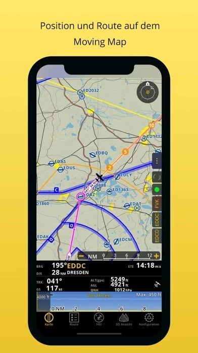
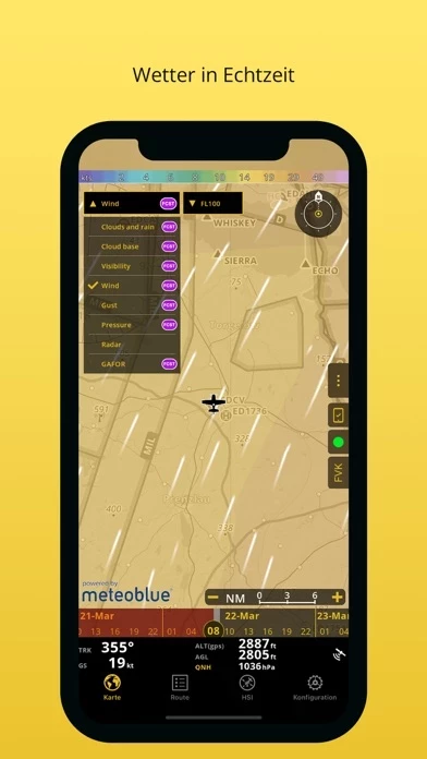
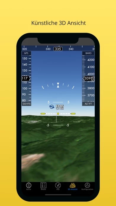
MORE TIME TO FLY, LESS TIME TO PLAN - Everything you need to fly in the entire world in one app - Plan your flight within minutes - Fly relaxed with updated and live information Air Navigation Pro is a high-quality flight assistant app, with real time GPS navigation for VFR pilots all over the world. You will find the following main features : MOVING MAP AND FLIGHT PLANNING FUNCTIONS The Moving Map displays aeronautical charts as background, interactive waypoints, airspaces and planned route. Plan and edit with the Flight Planning function, directly from the moving map or by searching the waypoint’s database. The planned route will be displayed on the moving map together with further information such as next point distance, track, heading and many more. APPROACH CHARTS The georeferenced approach charts are designed for maximum visibility. Displaying now also in the 3D view, they provide increase awareness of your surroundings during take-off and landing. NEW : Create a route and Air Navigation Pro will install related approach charts automatically (if part of your subscription). AERONAUTICAL CHARTS, PROFILE VIEW AND 3D VIEW We provide a worldwide selection of free and paid charts including the main ICAO charts. The Profile View gives all terrain information for better situation awareness and safety enhancement. The 3D view provides enhanced terrain awareness and is compatible with georeferenced approach charts. WEATHER (included in all Premium and Smart+ packages): R...