How to Cancel GOHUNT / GPS Hunting Map
Published by goHUNT on 2023-12-04We have made it super easy to cancel GOHUNT / GPS Hunting Map subscription
at the root to avoid any and all mediums "goHUNT" (the developer) uses to bill you.
Complete Guide to Canceling GOHUNT / GPS Hunting Map
A few things to note and do before cancelling:
- The developer of GOHUNT / GPS Hunting Map is goHUNT and all inquiries must go to them.
- Cancelling a subscription during a free trial may result in losing a free trial account.
- You must always cancel a subscription at least 24 hours before the trial period ends.
How easy is it to cancel or delete GOHUNT / GPS Hunting Map?
It is Very Easy to Cancel a GOHUNT / GPS Hunting Map subscription. (**Crowdsourced from GOHUNT / GPS Hunting Map and Justuseapp users)
If you haven't rated GOHUNT / GPS Hunting Map cancellation policy yet, Rate it here →.
Pricing Plans
**Gotten from publicly available data and the appstores.
Explorer subscription
Price: $49/year
Features:
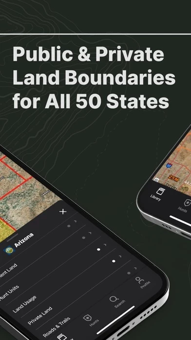
- Land boundaries
- Hunts planning and sharing
- Data import
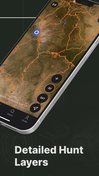
- Hunting layers
- Offline GPS maps
- 3D terrain
- Mapping tools
- Basemaps
- Record tracks
- Map settings
- State coverage for all 50 states
Potential Savings
**Pricing data is based on average subscription prices reported by Justuseapp.com users..
| Duration | Amount (USD) |
|---|---|
| If Billed Once | $49.99 |
How to Cancel GOHUNT / GPS Hunting Map Subscription on iPhone or iPad:
- Open Settings » ~Your name~ » and click "Subscriptions".
- Click the GOHUNT / GPS Hunting Map (subscription) you want to review.
- Click Cancel.
How to Cancel GOHUNT / GPS Hunting Map Subscription on Android Device:
- Open your Google Play Store app.
- Click on Menu » "Subscriptions".
- Tap on GOHUNT / GPS Hunting Map (subscription you wish to cancel)
- Click "Cancel Subscription".
How do I remove my Card from GOHUNT / GPS Hunting Map?
Removing card details from GOHUNT / GPS Hunting Map if you subscribed directly is very tricky. Very few websites allow you to remove your card details. So you will have to make do with some few tricks before and after subscribing on websites in the future.
Before Signing up or Subscribing:
- Create an account on Justuseapp. signup here →
- Create upto 4 Virtual Debit Cards - this will act as a VPN for you bank account and prevent apps like GOHUNT / GPS Hunting Map from billing you to eternity.
- Fund your Justuseapp Cards using your real card.
- Signup on GOHUNT / GPS Hunting Map or any other website using your Justuseapp card.
- Cancel the GOHUNT / GPS Hunting Map subscription directly from your Justuseapp dashboard.
- To learn more how this all works, Visit here →.
How to Cancel GOHUNT / GPS Hunting Map Subscription on a Mac computer:
- Goto your Mac AppStore, Click ~Your name~ (bottom sidebar).
- Click "View Information" and sign in if asked to.
- Scroll down on the next page shown to you until you see the "Subscriptions" tab then click on "Manage".
- Click "Edit" beside the GOHUNT / GPS Hunting Map app and then click on "Cancel Subscription".
What to do if you Subscribed directly on GOHUNT / GPS Hunting Map's Website:
- Reach out to goHUNT here »»
- Visit GOHUNT / GPS Hunting Map website: Click to visit .
- Login to your account.
- In the menu section, look for any of the following: "Billing", "Subscription", "Payment", "Manage account", "Settings".
- Click the link, then follow the prompts to cancel your subscription.
How to Cancel GOHUNT / GPS Hunting Map Subscription on Paypal:
To cancel your GOHUNT / GPS Hunting Map subscription on PayPal, do the following:
- Login to www.paypal.com .
- Click "Settings" » "Payments".
- Next, click on "Manage Automatic Payments" in the Automatic Payments dashboard.
- You'll see a list of merchants you've subscribed to. Click on "GOHUNT / GPS Hunting Map" or "goHUNT" to cancel.
How to delete GOHUNT / GPS Hunting Map account:
- Reach out directly to GOHUNT / GPS Hunting Map via Justuseapp. Get all Contact details →
- Send an email to [email protected] Click to email requesting that they delete your account.
Delete GOHUNT / GPS Hunting Map from iPhone:
- On your homescreen, Tap and hold GOHUNT / GPS Hunting Map until it starts shaking.
- Once it starts to shake, you'll see an X Mark at the top of the app icon.
- Click on that X to delete the GOHUNT / GPS Hunting Map app.
Delete GOHUNT / GPS Hunting Map from Android:
- Open your GooglePlay app and goto the menu.
- Click "My Apps and Games" » then "Installed".
- Choose GOHUNT / GPS Hunting Map, » then click "Uninstall".
Have a Problem with GOHUNT / GPS Hunting Map? Report Issue
Leave a comment:
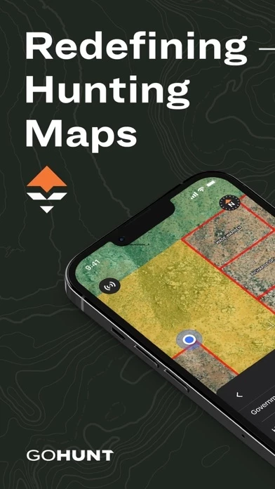
What is GOHUNT / GPS Hunting Map?
For all hunters who aspire to grow their skills and seek new adventures, GOHUNT is the most reliable interactive hunting platform because every aspect of its offerings is led by expert hunters and built by world-class technologists. Our tools serve hunters across their planning, preparation, scouting, mapping, and time in the field. GOHUNT's hunting GPS maps are the best in class, and are built to withstand the harshest environments with or without cell service. Try it yourself with our 7-day free trial, and see firsthand why our maps are the most innovative solution for the challenges you face both in the field and planning from home. Our Explorer subscription ($49 /year) gives you access to the following features to plan, prepare, and succeed on your next hunt. We currently provide coverage for all 50 states! LAND BOUNDARIES Public/private land boundaries, hunt units and districts, and more show you exactly where you can and can’t hunt HUNTS Plan and share your entire hunt plan with other GOHUNT users across all your devices (desktop and mobile) IMPORT DATA Simple data & waypoints import your from other mapping apps using a computer. Hunters can import any .gpx or .kml compatible file. HUNTING LAYERS Easily filter for public and private land, government land, walk-in access properties, hunt zones (antelope, bighorn sheep, deer, black bear, elk and more) with species distribution, hunt units, land usage (grazing allotments and timber cuts), terrain of upwards of 11,500...