How to Cancel onX Offroad
Published by onXmaps, Inc. on 2023-12-11We have made it super easy to cancel onX Offroad: Trail Maps & GPS subscription
at the root to avoid any and all mediums "onXmaps, Inc." (the developer) uses to bill you.
Complete Guide to Canceling onX Offroad: Trail Maps & GPS
A few things to note and do before cancelling:
- The developer of onX Offroad is onXmaps, Inc. and all inquiries must go to them.
- Check the Terms of Services and/or Privacy policy of onXmaps, Inc. to know if they support self-serve subscription cancellation:
- Cancelling a subscription during a free trial may result in losing a free trial account.
- You must always cancel a subscription at least 24 hours before the trial period ends.
How easy is it to cancel or delete onX Offroad?
It is Difficult to Cancel a onX Offroad subscription. (**Crowdsourced from onX Offroad and Justuseapp users)
If you haven't rated onX Offroad cancellation policy yet, Rate it here →.
Potential Savings
**Pricing data is based on average subscription prices reported by Justuseapp.com users..
| Duration | Amount (USD) |
|---|---|
| If Billed Once | $0.00 |
| Monthly Subscription | $16.29 |
| Yearly Subscription | $29.99 |

How to Cancel onX Offroad: Trail Maps & GPS Subscription on iPhone or iPad:
- Open Settings » ~Your name~ » and click "Subscriptions".
- Click the onX Offroad (subscription) you want to review.
- Click Cancel.
How to Cancel onX Offroad: Trail Maps & GPS Subscription on Android Device:
- Open your Google Play Store app.
- Click on Menu » "Subscriptions".
- Tap on onX Offroad: Trail Maps & GPS (subscription you wish to cancel)
- Click "Cancel Subscription".
How do I remove my Card from onX Offroad?
Removing card details from onX Offroad if you subscribed directly is very tricky. Very few websites allow you to remove your card details. So you will have to make do with some few tricks before and after subscribing on websites in the future.
Before Signing up or Subscribing:
- Create an account on Justuseapp. signup here →
- Create upto 4 Virtual Debit Cards - this will act as a VPN for you bank account and prevent apps like onX Offroad from billing you to eternity.
- Fund your Justuseapp Cards using your real card.
- Signup on onX Offroad: Trail Maps & GPS or any other website using your Justuseapp card.
- Cancel the onX Offroad subscription directly from your Justuseapp dashboard.
- To learn more how this all works, Visit here →.
How to Cancel onX Offroad: Trail Maps & GPS Subscription on a Mac computer:
- Goto your Mac AppStore, Click ~Your name~ (bottom sidebar).
- Click "View Information" and sign in if asked to.
- Scroll down on the next page shown to you until you see the "Subscriptions" tab then click on "Manage".
- Click "Edit" beside the onX Offroad: Trail Maps & GPS app and then click on "Cancel Subscription".
What to do if you Subscribed directly on onX Offroad's Website:
- Reach out to onXmaps, Inc. here »»
- Visit onX Offroad website: Click to visit .
- Login to your account.
- In the menu section, look for any of the following: "Billing", "Subscription", "Payment", "Manage account", "Settings".
- Click the link, then follow the prompts to cancel your subscription.
How to Cancel onX Offroad: Trail Maps & GPS Subscription on Paypal:
To cancel your onX Offroad subscription on PayPal, do the following:
- Login to www.paypal.com .
- Click "Settings" » "Payments".
- Next, click on "Manage Automatic Payments" in the Automatic Payments dashboard.
- You'll see a list of merchants you've subscribed to. Click on "onX Offroad: Trail Maps & GPS" or "onXmaps, Inc." to cancel.
How to delete onX Offroad account:
- Reach out directly to onX Offroad via Justuseapp. Get all Contact details →
- Send an email to [email protected] Click to email requesting that they delete your account.
Delete onX Offroad: Trail Maps & GPS from iPhone:
- On your homescreen, Tap and hold onX Offroad: Trail Maps & GPS until it starts shaking.
- Once it starts to shake, you'll see an X Mark at the top of the app icon.
- Click on that X to delete the onX Offroad: Trail Maps & GPS app.
Delete onX Offroad: Trail Maps & GPS from Android:
- Open your GooglePlay app and goto the menu.
- Click "My Apps and Games" » then "Installed".
- Choose onX Offroad: Trail Maps & GPS, » then click "Uninstall".
Have a Problem with onX Offroad: Trail Maps & GPS? Report Issue
Leave a comment:
Reviews & Common Issues: 1 Comments
By Kenneth Downs
2 years agoI do not want this app. I did not know it was a pay app. I still do not know how much it costs. I got a message that it is a seven day trial. I'm trying to figure out how to cancel because I do not want it.
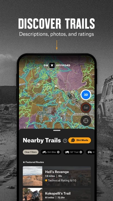
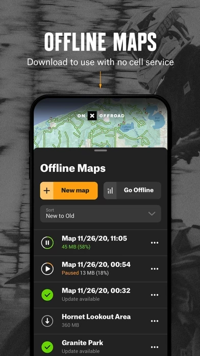
What is onX Offroad: Trail Maps & GPS?
GPS mapping App that lets you easily find the off-road trails you're looking for—whether you want to discover what’s open nearby or explore somewhere new. Filter 615K miles of nationwide trails by accessibility for 4x4, SxS, dirt bikes, moto, ATV/Quads, Overland, and snowmobiles. ▶Navigate Without Cell Coverage Save Offline Maps to bring your custom maps and adventure along when you're outside cell coverage on the trail. With the onX Offroad App, you turn your phone into a handheld GPS device using your phone's internal GPS. Navigate offline by following the blue dot to always know how to get home–wherever home is that night. ▶Adventure is Tap Away with Our Library of Map Data With map data sourced from USFS, MVUM, BLM, and NPS, our color-coded basemap includes off-road trails, Public Land boundaries, and recreation points to let you quickly scan for open routes near you and locate dispersed camping or campgrounds. Tap anywhere on the map to find hiking trailheads, trailer parking, non-ethanol fuel stations, boat launches, fishing access, and more. Scout the landscape and visualize mountains by viewing your maps in 3D, topo, satellite imagery, or a hybrid. ▶Private Property Maps With Boundaries-Elite Only Make your maps Elite to discover more off-road access with private property boundaries and data for the whole country. Always know where you can legally off-road and camp, and find out who owns OHV trails or the property next to a trail easement with our Private Land...